
The Universidade Federal do Amazonas-based research team has developed an Artificial Neural Network (ANN) model that utilizes satellite imagery and deep learning techniques to detect wildfires in the Amazon rainforest with a high success rate.
“The ability to detect and respond to wildfires is crucial for preserving the delicate ecological balance of these vital ecosystems, and the future of this Amazon region depends on decisive rapid action.”
– Lead author Professor Cíntia Eleutério of the Universidade Federal do Amazonas
While monitoring in the Amazon is still provided with real-time data today, it has moderate resolutions, and the ability to detect details in smaller fire outbreaks or remote areas is limited.
So, the model represents a powerful solution for automatically detecting wildfires, significantly reducing the time needed to mitigate their devastating effects.
Published in the International Journal of Remote Sensing, the study findings report a success rate as high as 93% in training the model on Amazon rainforest images with and without wildfires. According to co-author Professor Carlos Mendes:
“The CNN model could serve as a valuable addition, enabling more detailed analyses in specific regions. By combining the wide temporal coverage of the current sensors with the spatial precision of our model, we can significantly enhance wildfire monitoring in critical environmental preservation zones.”
The study noted that the integration of satellite images and AI presents a proactive approach to addressing the escalating challenges posed by forest fires while contributing to the field of remote sensing and deep learning.
The technology particularly offers the potential to enhance early warning systems and improve wildfire response strategies, aiding in the preservation of critical ecosystems like the Amazon. Integration into existing monitoring systems could easily take 1 to 3 years, depending on further validation and deployment efforts. But let’s take a deeper look into the advancements the new tech offers to the world.
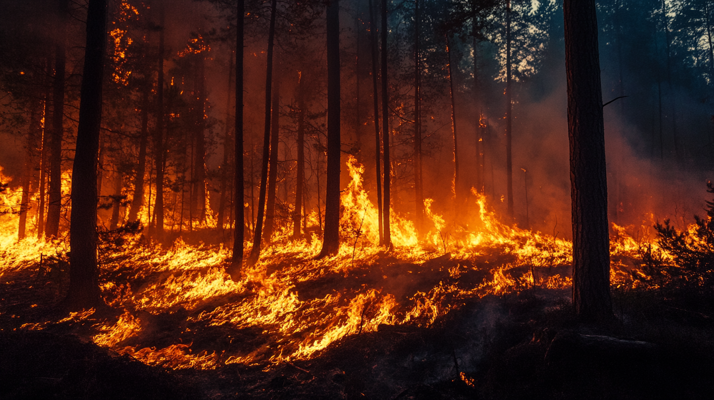
The Lungs of the Earth Facing a Serious Threat
The Amazon rainforest is a globally significant asset, containing several million species of birds, insects, plants, and other forms of life. It is the world’s richest and most-varied biological reservoir.
People around the world depend on this rainforest not just for food, water, wood, and medicines but also to help stabilize the climate with a massive 150-200 billion tons of carbon stored in it.
The Amazon rainforest exerts a strong socio-environmental and economic influence on Brazil, comprising about 40% of the total area of the South American country. Besides Brazil, the rainforest spans eight other South American countries.
Given its major role in biodiversity preservation and global climate regulation, the Amazon rainforest is of great ecological importance.
However, it is facing a surging crisis in the form of rampant deforestation, unsustainable land-use practices, and the imminent threat of wildfires.
Over the last half a century, the increase in temperature has led to the intensification of droughts in the region. Things are only going to escalate further, with most models predicting an increase in the intensity of the dry season in the Amazon Rainforest in the 21st century.
This escalation is due to radiation forces and decreased production of aerosol, which causes anomalous variations in sea surface temperatures (SST), leading to fluctuations in the precipitation amount over the Amazon region.
If this new climate configuration is confirmed, the study noted, the rainforest can become an amplified system prone to wildfires. This exposes the lungs of the Earth to a rising threat because of the increasing number of wildfires.
The environmental repercussions of these fires aren’t limited to the regional boundaries either; rather, they impact global climate patterns and biodiversity. This makes it crucial to detect and respond to wildfires in the Amazon.
To monitor and address this environmental crisis, remote sensing through satellite imagery has emerged as a vital tool for preserving the delicate ecological balance of this vital ecosystem.
Click here to learn why fire safety is more crucial than ever.
The Grievous Effect of Intensifying Wildfires
Based on data from the National Institute for Space Research (INPE) on the TerraBrasilis web platform, forest fires between January and June remained low from 1999 to 2023. However, the number of incidents increased considerably between July and November before decreasing in December.
The number of wildfire incidents was low throughout the year between 1999 and 2001. The wildfire intensity increased significantly starting in 2002, reaching a local maximum in 2005.
The decrease lasted until 2011 when the numbers started to experience a steady increase, and this ascending trend is still ongoing. The last five years have had the highest incidences of wildfires. In 2023, there were 98,639 wildfires in the Amazon.
The Amazon rainforest also accounts for a significant portion (over half) of wildfires in the Brazilian biomes.
Besides the Amazon, other ecosystems hosted by Brazil include the Cerrado, which accounted for 26.70% of all wildfires, as well as the Caatinga, Atlantic Forest, Pantanal, and Pampas, with the last two being the least affected by wildfires in 2023.
Each of these ecosystems has its unique species diversity and characteristics. These biomes are essential in mitigating climate change, acting as carbon sinks, and safeguarding endangered species. However, wildfires are causing significant damage to all these ecosystems.
Location-wise, the highest concentration of wildfires in the state of Amazonas is found in the municipalities of Lábrea, Apuí, and Novo Aripuanã, which recorded the highest number of incidences.
Forest fires are extremely detrimental and have devastating consequences on multiple fronts.
For starters, it destroys vegetation, which can lead to an irreversible extinction of native species. Some of this vegetation has unique medicinal properties and is found only in the Amazon region.
Wildfires also compromise soil fertility, rendering it barren and obstructing the natural recovery of affected areas. Furthermore, Amazon deforestation caused by the wildfires increased water runoff, raising river levels. This is because of the reduction of vegetation cover, which negatively affects water infiltration into the soil, reducing evapotranspiration rates.
Then there’s the loss of fauna and flora, which is equally alarming. Forest fires cause the destruction of vital habitats, leading to considerable imbalances in the local food chain.
The intense CO2 emissions into the atmosphere also aggravate the greenhouse effect and global warming. This intensifies the global climate challenges and makes large fires even more frequent in the Amazon rainforest.
Leveraging Deep Learning for Automated Wildfire Detection
To address the problem, the study employed a new technology, the Convolutional Neural Network (CNN), to classify wildfires in the region.
CNN is a specialized subset optimized for image analysis and visual pattern recognition, which has become a powerful tool in computer vision.
For instance, the CNN model was used to classify and diagnose COVID-19. Besides this, it has been used to detect pneumonia using chest X-ray images, intelligent waste identification and recycling, analyze collisions in High Energy Physics, and cell type identification in stem cell images.
It is also being used for the change detection of deforestation in the Brazilian Amazon using Landsat data, wildfire detection, and forest fire smoke detection for unmanned aerial vehicle (UAV) images.
CNN utilizes deep learning, a subset of Artificial Intelligence (AI) and Machine Learning that employs algorithms that get better over time as they get exposed to new and increasing data.
For this study, the researchers took advantage of the algorithm Artificial Neural Networks (ANN), which mimics the way the human brain operates and enables computational models to discern intricate patterns and address challenges that may be beyond human comprehension.
It stacks multiple layers sequentially to facilitate knowledge assimilation to work with extensive datasets during the training process.
This technological synergy makes use of statistical procedures to help machines accomplish tasks like identifying wildfires through experiential learning.
By leveraging the great potential of deep learning techniques, the network offers a powerful solution for the automated detection of wildfires. The automated identification allows for a timely response to mitigate the devastating effects of wildfires.
In the latest study, the researchers expanded upon the neural network framework to focus on CNN, specifically utilized through the Python libraries TensorFlow and Keras, a model type widely used in computer vision applications for extracting features from images.
The goal has been to employ CNN to detect wildfires in the Amazon region using Landsat 8 and Landsat 9 satellite imagery.
Click here to learn how heat-activatable biomimetic hydrogels tackle wildfires
Advanced and Localized Approach to Wildfire Detection
The team used images sourced from Landsat 8 and Landsat 9 satellites to train the model.
These satellites are packed with advanced instruments to capture images across various spectral bands, necessary for the detection and classification of wildfires. The multispectral and thermal capabilities of these satellites enable the identification of temperature anomalies and the differentiation between vegetation types and burned areas.
Both of these satellites feature the Operational Land Imager (OLI), which captures images in visible, near-infrared (NIR), and shortwave infrared (SWIR) bands, which is critical in detecting vegetation changes.
Burned areas show low reflectance in the NIR, while healthy vegetation is strongly reflected. The shortwave infrared (SWIR) bands meanwhile help detect moisture in soil and vegetation for the identification of fire-affected regions.
Both satellites also have the Thermal Infrared Sensor (TIRS), which operates in two thermal infrared bands and provides valuable data on heat sources and surface temperature. The TIRS offers a spatial resolution of 100 meters, while the OLI bands have a spatial resolution of 30 meters. As such, they are most relevant for wildfire monitoring and allow for more detailed mapping of vegetation health.
The team trained CNN using a dataset of 200 recent images obtained from EarthExplorer, which showed wildfires in the Amazon Rainforest. An equal number of images without wildfires were also used to ensure a balanced learning approach.
The dataset, while small, was sufficient enough for the CNN to achieve 93% accuracy during the training phase. When tested on 40 images not included in the training, the model was able to accurately classify 23 of the 24 images with wildfires and all of the 16 images without wildfires.
This highly satisfactory level of performance showcases the robustness and generalization capabilities of the model.
This approach, the team said, exhibits a great potential for wildfire detection and can be used in complement to well-established large-scale monitoring systems like Moderate Resolution Imaging Spectroradiometer (MODIS) and Visible Infrared Imaging Radiometer Suite (VIIRS), which are widely used in Brazil for broad, continuous fire detection.
As an additional tool, CNN can be used along with MODIS and VIIRS to enhance early warning systems and improve wildfire response strategies.
The methodology, the researchers further noted, goes beyond the Amazonian ecosystem with the potential to be used in other areas of the world. It can actually assist competent authorities in fighting and managing such incidents, “providing an advanced and more localized approach to wildfire detection,” the study said.
The CNN could also be explored in monitoring and controlling deforestation, suggested the researchers. Their next step is increasing the number of training images to have “a more robust model.”
Click here to learn how AI & growing occurence database may help diminish the risk of wildfires.
Innovative Company
Palantir Technologies Inc. (PLTR +8.31%)
With its AI-driven geospatial analytics and disaster response solutions, Palatir represents a strong player in environmental monitoring and wildfire detection.
Founded in 2003 by Alex Karp, Peter Thiel, Stephen Cohen, and Joe Lonsdale, Palantir is a software provider through Gotham, Foundry, Apollo, and AIP (Artificial Intelligence Platform). With a market cap of $186.6 billion, Palantir shares are currently trading at $81.25, up 5.28% YTD. It has an EPS (TTM) of 0.19 and a P/E (TTM) of 421.05.
Palantir Technologies Inc. (PLTR +8.31%)
In early Feb. the company announced its Q4 2024 financial results, reporting $828 million in revenue, which grew 36% YoY and 14% QoQ. Its number of customers also jumped 43% YoY and 13% QoQ.
Palantir’s US revenue was $558 million, increasing 52% YoY and 12% QoQ, with the US commercial revenue at $214 million, growing more than the US government revenue at $343 million.
During this period, the company closed 32 deals of at least $10 million, 58 deals of at least $5 million, and 129 deals of at least $1 million. It also closed a record $803 million of US commercial total contract value (“TCV”) while the US commercial remaining deal value (“RDV”) was $1.79 billion.
Palantir reported $460 million in cash from operations and $79 million GAAP net income, while its GAAP earnings per share was $0.03 and Adjusted EPS was $0.14. The company ended the year with $5.2 billion in cash, cash equivalents, and short-term US Treasury securities.
For the entire 2024, Palantir had $2.87 billion in revenue, $1.90 bln in US revenue, and $1.15 billion in cash from operations. Now, for Q1 2025, the company expects revenue between $858 and $862 million and adjusted free cash flow for full-year 2025 to be between $1.5 and $1.7 billion.
“Our business results continue to astound, demonstrating our deepening position at the center of the AI revolution. Our early insights surrounding the commoditization of large language models have evolved from theory to fact.”
– CEO Karp
When it comes to most recent developments, earlier this month, Palantir announced the rollout of its first two AI-enabled systems to the US Army. Palantir USG CTO Akash Jain called this a “leapfrog moment” for the US Army. The company won the $178 million contract a year ago, beating the defense giant RTX Corporation, to mark a key milestone for Palantir, which is known for its data analysis services.
The agreement is for 10 Targeting Access Node systems (TITAN) that utilize AI to gather data from space sensors in order to help soldiers achieve better strike targeting and accuracy. Acting as a mobile ground station, these systems help advance soldiers’ warfare strategy. Palantir collaborated with L3Harris (LHX -0.06%), Northrop Grumman (NOC -1.15%), and Anduril Industries to develop some of the capabilities.
This week, Palantir shared a list of new customers who attended its AI event, which revealed Walgreens (WBA -0.27%), Heineken, Ripcord, and RaceTrac, among others, as its latest clients.
It also partnered with Archer Aviation (ACHR +8.97%) to build the AI foundation for the future of next-gen aviation technologies and help scale its aircraft manufacturing abilities. The plan is to leverage AIP and Foundry to develop software using AI to advance aviation systems like air traffic control, route planning, and movement control.
“Palantir’s partnership with Archer is redefining the future of flight, making it not only more efficient but also more accessible,” said Karp, adding that this integration sets “the stage for a transformative leap in efficiency, safety, and sustainability.”
Latest on Palantir Technologies Inc.
Gifford: Correction Healthy for Market, TSLA, PLTR & MSTR Top Picks
youtube.com • March 14, 2025
PLTR Rallies Off R1 Partnership, Expands A.I. Footprint
youtube.com • March 14, 2025
These 2 Stocks Are in Free Fall, and It’s Still Too Early to Buy Them
fool.com • March 14, 2025
Options Trades: NVDA & PLTR Rebound
youtube.com • March 14, 2025
Here’s how much an early 2025 investment in Palantir stock would be worth today
finbold.com • March 14, 2025
Live Nasdaq Composite: TSLA, NVDA and PLTR Rise
247wallst.com • March 14, 2025
Conclusion
Amazon, with its rich biodiversity and extensive resources, contributes to the global economic landscape. So, the conservation and sustainable management of these areas are not only beneficial to Brazil but also critical to our entire planet’s health.
The Amazon rainforest, however, is facing the threat of wildfires, which poses a serious challenge to its stability. This means the future of the region depends on decisive, rapid action.
Here, the deep learning-based wildfire detection model represents a major breakthrough in addressing this crisis. By achieving a 93% accuracy rate, the model provides a powerful tool for early detection and rapid response to wildfires, which could help prevent catastrophic environmental damage and help maintain the long-term health and stability of the Amazon rainforest.